Cryptoforests in Manchester

/ Monday, August 29, 2011 /

Cryptoforestry. Say it aloud once, you won't be disappointed. It sounds like spies should be implanting sensitive information into the DNA of trees to be later decoded by their colleagues, or that some pine farmer is planting his trees in specific patterns only to be deciphered by the satellites above. 

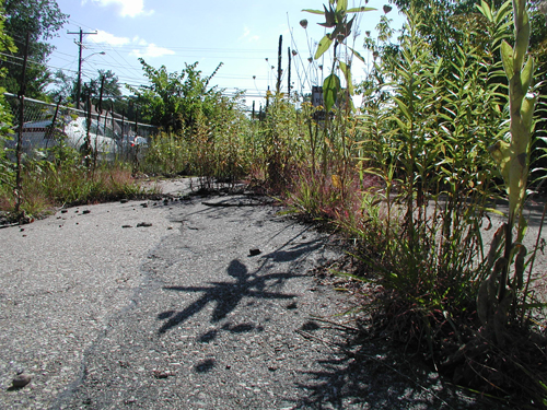
Admittedly, the beautiful neologism sounds more attractive than the actual meaning. In the shadows and forgotten corners of urban development, a weedy revolution is taking place. Trees, grass and wild flowers sprout from the cracks of old pavement and forlorn planters. Young saplings push through the checkered, linoleum tiles of some condemned gas station without the aid of human hands, slowly pulling the property back into the forest. These feral patches of trees and plants are cryptoforests, once developed and maintained areas, now languishing, overlooked and hidden in private ownership, are slowly reverting back to the vegetative constant of the environment. When it has the chance, nature finds a way.


Considering Manchester's lengthy history it's surprising that the city doesn't have more cryptoforests, a testament to the city's developmental abilities and entrepreneurism (Detroit might be another story), but I've spied a few. Beyond the South Manchester Rail Trails, is a rich and large cryptoforest sprouting with unnatural looking dogwoods, weeds and pines between and behind old industrial buildings, half of which look abandoned. Underneath an overpass on Elm street, plants and small trees, with a more water based nature, overgrow an abandoned railroad line, fenced off from the human interaction. The Union Leader recently published a short article about the old gas station and the maturing cryptoforest on the corner of Lake Ave. and Hanover St., ruling it an eyesore.


It's easy to condemn these botanical reclamations of space, but after briefly wandering through the lot on Hanover and Lake, I was surprised by the unexpected and eerie beauty of the whole thing. I felt like I was exploring the ruins of a distant, post-human future while the endless rumble of motors beyond the weathered chain-link fence mired me in the present. I was also surprised by how large the space felt once inside its confined forest, with all it's new nooks and crannies to explore.


The ecology of the cryptoforests are also kind of curious. What are considered weeds or invasive plants, tend to be the first to pop up, like hard to kill marines, overtaking the area and exploiting every crevice in the pavement and other structures before the calvary of larger trees and bushes arrive. It's funny to think of weeds as mother nature's botanic foot-soldiers.

Have you seen a cryptoforest in Manchester? Send pics to daniel dot brian at gmail dot com and I'll post a few here in the near future.

Further reading: Cryptoforestry blog

Weston Observatory

/ Tuesday, August 23, 2011 /


Often the most engaging history lesson is one you can see, touch or walk through. The Battle of Bunker Hill is always associated with the 294 steps I climbed in the obelisk that memorializes it, and the dull ache in my legs when I reached the top. I remember the warm, metallic smell on the lower decks of the USS Wisconsin, an Iowa Class battleship commissioned in World War II, marveling at the idea that men had once hunkered down there during the bombardment of Okinawa and how the texture of the Vietnam Memorial lingered on my fingers for a seemingly impossible amount of time afterwards. These are the types of moments that people never forget.

Granted, Manchester is not the navel hub that Norfolk is or the historical convergence that Boston was, but the city has a rich history that is often memorialized with simple statutes sitting stagnant in the middle of its parks, but I discovered this is not entirely the case. On a recent schedule-wrecking, focus-stealing jaunt through Google Earth, I happened upon a photo of something called the Weston Observatory, a rogue lighthouse looking structure that had escaped the coast.


Curious, my girlfriend and I hopped in the car one morning and drove up to Derryfield Park. We were greeted with a motorized gate and no signs indicating the existence of the observatory. We parked to the side of the small road and slipped by the gate on foot. Sure enough, it was there, along with an overgrown clearing, several graffiti laden boulders and two memorialized canons overlooking a barbed-wire clad Oak Hill Water Reservoir (certainly, what the motorized gate was all about). The observatory is surrounded by an old, intimidating wrought, iron fence and a locked gate. The door is boarded up along with the windows. We searched for an information kiosk or plaque to give us a little back story to the structure's history, but there was nothing, just the word "WESTON" carved into the stone above the door. The place felt forgotten, a reminder that every building and space is on a trajectory.


Manchester's website has a quick blurb about the tower and James Adams Weston, a four time mayor of Manchester and twice elected governor of NH in the mid 19th century. Weston left $5000 for the observatory to built after he passed in 1895. Considering the state of his monument, I found it serendipitous that Weston (a gifted engineer by trade) happened to be renowned for commissioning many city beautification projects. He was also instrumental in modernizing Manchester's water and sewage infrastructure, the subject of a future post or two.

Despite the tower itself being in amazing shape, it's sad to see a piece of history locked up and neglected. Think of the micro field trips the local schools are missing or the theatrical first kisses teenagers are being denied atop the Weston Observatory. Imagine donning a parka and throwing a telescope over your shoulder for a casual night of looking at the stars or giving your kids a sense of geography during a simple picnic.


Understandably, the city government already cares for several recreational areas, and one more potentially under-utilized and difficult to maintain property is last thing on the collective political mind, but I'm curious as to what department the minor maintenance of the observatory falls under. Looking at Google Maps, you can see the observatory is not technically within the borders of the Derryfield Park, though it feels it should be. Is it still Parks and Recreation's responsibility? Or perhaps it is the Water department's job based on the monument's proximity to the reservoir? Maybe, nobody.

A few facts about the Weston Observatory:
- The first cornerstone was laid September 7, 1896
- The tower stands 66 feet tall
- In World War II, it was used as a spotting post for air raid wardens
- It is made entirely of local New Hampshire granite
- Weston left $5000 for the observatory to be built when he died in 1895 (isn't this kind of like buying your own birthday cake?)
- The Knights Templar oversaw the project as Weston was a high-ranking Mason

Old Gothic Revival shelters the weary

/ Sunday, August 21, 2011 /
 Over the last year, I watched the old, vacant cottage next to my apartment be half demolished (with amazing precision), then restructured, rebuilt and refashioned into a new and useful tool. Families in Transition, a non-profit dedicated to providing affordable housing and emergency shelter, was donated the property by New Hampshire Housing. FIT repurposed the house into interim housing for struggling families. Once, much smaller, the old house now supports 16 family-sized units.

The house is a Gothic Revival style cottage (fitting it stands across from a Gothic style church) that was built in 1846. The most I can glean of its history is that a shoemaker, James F. Bursiel, lived there for several years in the 1860s before moving to Lewiston, Maine sometime around 1880. It also served as a youth runaway shelter sometime in the late 20th century.


I'm often amused by the house's charming facade in the stark shadow of its new, bulbous and domestic-gilded backside. Air conditioning systems, security cameras and bright lights protrude from the cheery, yellow, Venetian siding like blisters eluding to the gravity of the house's new purpose and the current state of the lives that it now holds inside.

Imagine a single mom with two kids, just laid off, evicted, newly divorced and her ex-husband is leaving eerie death threats on her voicemail. FIT approves her and the kids for temporary housing and they pull up in front of the old Gothic Revival on a sunny, summer afternoon. The molding hanging from the eves tantalizes the children's eyes and the porch invites a quiet evening of reading and peace of mind, a temporary reprieve from her rotten luck. Once an aging piece of under-utilized state property, the house now looks like a sliver salvation in the right eyes.

Manchester Oblique

/ Friday, August 19, 2011 /
Recently, I came across several articles about London's underground and how urban spelunkers are exploring and mapping a labyrinth of abandoned tube tunnels, decommissioned pneumatic rail transit systems, secret government bunkers, lost catacombs and ostentatious swimming pools constructed by the city's super-rich. It was a fascinating reminder that London (along with a lot of Europe) has been building and rebuilding on top of itself for more than ten centuries. The city's ground is no longer a solid piece of soil or bedrock, but a porous Swiss cheese of concrete, steel and stone that is being drilled into and built over.

America is still new and has yet to reach these mature stages of rebuilding and structural transition. If you open Google Maps and set a course for the west coast, you can see cities like Seattle and Las Vegas are beautifully designed grids, fortified with modern urban planning. They almost look like circuits boards, with components that can be easily swapped in and out. Need a new museum? Just bulldoze the old Hyatt building flat, send away the rubble and build your new museum from scratch. Scroll east across the nation and the cities begin to garble with their squiggly lines and abstract borders. "The roads! They curve," a friend of mine once exclaimed returning to New Hampshire after living several years out west. Point the cursor towards New England and the map starts to look more akin to a map of Europe. New England is getting older, and over the last 50 years, its cities have stopped expanding outward and have started to re-utilize their own space. Building up, not out.

Manchester is one of these aforementioned cities, traversing a delicate stage of re-imagining the space that it claims. From rooting out the old mills to make way for businesses and homes, to paving over out-of-service rail road lines in lieu of bicycle trails, Manchester is on the cusp of a type structural change that most of America won't see for a long time. Manchester Oblique is an attempt to document and explore some of these transitions.


An oblique drawing is a two dimensional projection of a three dimensional object. I felt the term was appropriate as I intend to add extra dimensions and depth to the changing spaces we walk or drive by everyday, but never question. Two parts BLDG BLOG (architectural appreciation, conjecture and urban speculation) and one part My Good Good Manchester (hyper localized awareness and discourse), I hope to touch upon everything from Manchester's reuse of the mills to the effects of the city's watershed on local ponds.

I'll try to keep it as entertaining as possible.
 
Copyright © 2010 Manchester Oblique, All rights reserved